An idle thought. Doesn't the geography of the Blue Hill Peninsula in Maine bear an uncanny resemblance to that of Greece? The most striking difference is that Greece is 120 miles wide and the Blue Hill Peninsula is about 12. It's as if the glacier that carved the Blue Hill Peninsula were trying to engineer the Greek landscape at 1/10 scale.
If other have noticed these parallels before, I haven't been able to find their observations. But if I'm overlooking something, please drop me a line. (I'm also looking for a small silhouette of the Blue Hill Peninsula to go with my silhouette of Greece below.) Meantime, here are some of the major parallels.

|
|
In the table above, some of my Greek placenames are Anglicized and some are not. This is due to the different usages on the different maps I consulted. One day I hope to make the names consistent.
Here are two online maps that come close to giving the sense of this deep geographic similarity. But they don't let you make the comparison in detail. You really need a large print atlas and a cup of coffee.
|
|
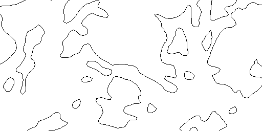
Blue Hill Peninsula
|
|
|
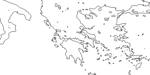
Greece
|
Here are some other, less adequate online maps of the two regions.
- From Captain D's Guide. Just the peninsula, very few outlying islands.
- From Hypernet. A local ISP. No place names.
- From The Insider's Guide to Maine's Mid-Coast. Small image, much more than the peninsula itself, cluttered with place names.
- From the Maine Resource Guide. Emphasizing roads. More on the Bangor area than the peninsula.
- From Excite. Small.
- From Hellas Map . No place names attached.
- From Hellas Online. Low-res. But also see Hellas Online's detailed geographical map.
- From the Hellenic Ministry of Culture. Clickable submaps. Skimpy on place names.
Maps of the Blue Hill Peninsula
Maps of Greece
![[Blue
Ribbon]](/~peters/blueribb.gif)