 Click for an enlargement.
Peter Suber, Antarctic Log
This is the log of my trip to Antarctica in January of 1996. It's easier to click "Back" and begone than to feign interest during a slide show, so please don't hang around just to be polite.
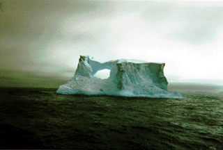
The picture above shows an iceberg with a natural arch in the open sea west of the Briscoe Islands. The top of the berg is about 150 feet above the water line.
I was afraid to get a good camera wet, based on experiences in Alaska and the Yukon which I thought would be similar to what I'd face in Antarctica. So I left my good camera at home and took seven disposable cardboard cameras: as many as my pack would hold, given my other gear. This was a mistake. I would not have gotten a good camera wet; my pack would have held many more than seven rolls of film; and the scenery was so spectacular, and hard to get to, that it deserved any effort on my part to photograph. Anyway. These cardboard cameras work pretty well, but they cannot adjust for the dazzling light of an Antarctic summer day reflecting off snow, ice, and water. So a good number of my pictures have their detail washed out. Some others would have required focusing or depth of field adjustments which I couldn't make. About 3/4 of my pictures, about 100, turned out presentably; only 10-20 I would say are good.
Here's a little background to set the stage for the log to follow.
The trip was sponsored by a complicated collaboration of Mountain Travel Sobek and Marine Expeditions. Our ship carried 38 passengers. (Most tourist ships in Antarctic waters hold 400 passengers and rarely let passengers go ashore.) Some of us were there for adventure, but some were working biologists. You could say that the biologists were piggy-backing on a tourist ship, or that we adventure tourists were piggy-backing on a working research vessel. On the landings, we adventure tourists would hike and take pictures; the biologists would count penguin eggs and chicks.
Two of the biologists are funded by National Science Foundation, and their grant officer happens to be Polly Penhale, sister of Sara. [Sara Penhale is Earlham's Science Librarian.] Polly is the director of all NSF polar biology programs. She and I had an extensive email correspondence as I prepared for the trip.
Ten of the adventure travellers were family members: my mother and step-father, brother Jack, soon-to-be sister-in-law Lisa, step-brother Hub, sister-in-law Brenda, step-brother Bob, foster brother Mark, foster sister JoAnn —and myself. It sounds like a family reunion, and would have been, but in fact many siblings (including full, step, half, and foster sibs) and spouses had conflicts and couldn't come.
We put ashore in zodiacs: rubber rafts with outboard motors. They are fairly tough, and can push through sharp "bergie bits" (iceberg fragments) or take a hard landing on sharp rocks without damage.
Temperatures in Antarctica ranged from 0 to 45 degrees F, not counting windchill. It snowed just a scintilla's worth. Antarctica is a true desert which gets less than 5 inches of precipitation per year. The ice on the Antarctic plateau is 2-3 miles thick only because it has had millions of years to accumulate. Most Antarctic "blizzards" blow around the snow which has already fallen. For the 3 weeks I was gone, Richmond had colder temperatures and more snowfall than Antarctica.
When we were on the ship, in between landings, we were either sleeping, eating, retching, reading, or attending lectures or films on Antarctic wildlife, geology, history, or exploration. The Mountain Travel Sobek guides, and the working biologists, were extremely knowledgeable, and probably spent more time talking to us about whales, seals, penguins, sea birds, tectonic plates, international law, mountain climbing, dog mushing, and early heroic explorers than they spent on land doing their "work". The ship also had an excellent library of videotapes and books on Antarctic natural history.
I suspect this log would be easier to follow with a map, or more fun. And I know that a map of the Antarctic Peninsula which shows all the islands and bays I mention is very hard to come by. Sorry. I include all the place names for accuracy and color, not to frustrate. For general orientation: most of our landings were on islands or mainland sites on the inside passage of the Antarctic Peninsula, which is the west side of the Peninsula. Find a world map and go due south from the tip of South America; you'll see the Peninsula curving like a finger to the north and east from the Antarctic mainland. The west edge of the Peninsula is dotted with islands; the inside passage is the area between the islands and the mainland. (Believe it or not, to underline the difficulty of Antarctic exploration: nobody knew that the Peninsula was a peninsula, and not an island, until 1948.)
The log would also be more fun to follow with pictures. If I have time, I'll scan a few more of my best shots.
So herewith, my log:
1/13. Richmond to Dayton, to Chicago, to Miami, to Santiago. Almost 24 hours of flying and waiting in airports.
1/14. All day in Santiago.
1/15. Another day in Santiago. We arrived in Santiago a day earlier than necessary to avoid missing our planes out of the U.S. due to the terrible blizzards in the midwest and east. This was wise. Three siblings travelled out of Washington DC, whose airports shut down the day after they departed.
1/16. Fly from Santiago to Ushuaia (Argentina), the southernmost city in the world. The flight is lengthwise down the Andes, on a clear day: spectacular scenery. Ushuaia is a pretty city, about the size of Richmond, nestled at the foot of big mountains on the Beagle Channel. It seems to cater to skiers in the winter. It looks like Aspen, without the wealth, or Haines (Alaska), with wealth. That evening we board the Livonia, our Estonian ice-breaker, and head out the Beagle Channel toward Cape Horn and points south.
1/17. Early in the morning I'm awakened by rough seas tossing my body in my bunk. I don't feel seasick until I try to get up. The Drake Passage (the body of water between Cape Horn and Antarctica) thwarted all the famous early explorers who tried to round Cape Horn and circumnavigate the globe. One explorer accurately described it as "the zone of continual tempest". (The southern ocean below Cape Horn is the only place on Earth where waves can circle the planet without hitting land; consequently they can build up for years. Such waves are called "Graybeards" and I'm pretty sure we saw some.) We're in 10-15 foot swells, which the crew says are mild for the Drake. My inner ear and stomach don't know what mild is; I'm sick all day and spend it lying down. I'm taking prescription strength meclizine for motion sickness, but it's not helping. About a third of us, including crew, are similarly afflicted.
1/18. Second day on the Drake Passage. It's a two day crossing. A brother gives me a scopelemine (sp?) patch for seasickness. These have been taken off the market in the U.S. for causing hallucinations; but it works for me. I'm on my feet, though a little queasy. I spend most of the day on the bridge, watching the bow rise and fall. When the bow rams into an oncoming swell, water explodes into a gigantic spray which envelopes the entire ship. I'm too queasy to return to my cabin to get my camera to document this evidence of rough seas. Our ship is about the same size as the 18th and 19th century wooden sailing ships which originally explored these waters. I'm wondering what it felt like to hit really big water in a wooden ship which can crack and splinter; our steel ship seems to be groaning. The water is formidably dark and cold; one fantasizes about disaster. At mid-day we cross the "Antarctic convergence", the line where the Drake's comparatively warm (!), easterly current meets the frigid, westerly current which surrounds Antarctica; one knows one is passing the convergence (going south) when the ocean temperature drops below 4 degrees centigrade. Icebergs are becoming more plentiful. We spot two humpback whales spouting, too far away to photograph. (This was the case with all the whales seen on the trip.) Landfall toward evening: the South Shetland Islands. We try go ashore at Penguin Island, just south of King George Island, but the sea is too rough.
1/19. We're out of the Drake Passage, into the calmer waters of the Antarctic Peninsula and its nearby islands. My inner ear and stomach notice right away. I feel 100% and eat well for the first time on shipboard. We cross the Bransfield Strait and put ashore at Mikkelson Harbor, Trinity Island, our first landing. We walk among thousands of gentoo penguins. A Weddell seal is sleeping on the ice. When it wakes up and notices our presence, it snorts and goes back to sleep, even though we are just feet away from it, snapping pictures. These animals have no land predators and no fear of us. So we must take precautions not to disturb them. The Antarctic Treaty prohibits touching the animals without a permit; our biologists have a permit but never use it. We see a skeleton of a minke whale next to the skeleton of a 19th century whale boat, a sad but fitting juxtaposition. Both have been on this beach more than 150 years. Under the Antarctic Treaty, objects like these cannot be disturbed. We make a second landing this day at Cuverville Island, another gentoo rookery. We hear icebergs calving off a nearby glacier feeding into the Gerlache Strait; it sounds like a cannon firing. We see two more whales on the horizon, spouting, probably humpbacks; then later, two minke whales.
I won't keep mentioning it in every day's entry, but on every landing without exception we saw thousands of penguins, sometimes tens of thousands. In the Antarctic summer they come ashore on the islands and coastal areas which are free of ice and snow, to lay their eggs and raise their chicks. Since these areas are comparatively rare, penguins are very densely populated in them, standing on their nests, feeding their young, courting, and quarreling. Human travelers, and penguin biologists, head for the same pieces of land.
1/20. The Lemaire Channel is blocked by ice, so we back up and head out to sea. (We will try the Lemaire again on our way north again; it is supposed to be one of the most beautiful channels in Antarctica.) We speed southward on a course outside (to the west of) the Briscoe Islands, putting off further landings until we are quite a bit further south. We are in much rougher water again, and my queasiness returns. In mid-afternoon we cross the Antarctic Circle (66' 33.8"). Since this is the first time the Livonia or any of its crew has crossed this "landmark", we are on the bridge watching the GPS tick off the seconds of latitude to the goal; when we cross the Circle the captain cuts a ribbon we strung across the bridge and makes a nice little speech of thanks. His English is very broken, but he has a knack of rising to the occasion.
1/21. During the night we push further south, aiming for Stonington Island, in Marguerite Bay, where Byrd built a shack. But the captain wakes us up at 3:00 am, using the P.A. system. We are 15 miles from Stonington Island and the ocean is frozen all the way from here to there. In fact we are stuck in the pack ice. Would we like to come up on deck to see it? The sun is out, of course, and we face the eerie sight of an endless plain of flat ice, punctuated here and there by an iceberg trapped just as we are. We are stuck for about 8 hours. The captain's method for breaking out was to back the ship up a few feet, then ram the ice forward; then back up again, this time a few feet further, and then ram again. After 10 repetitions of this, or so, we had the momentum to keep breaking through the ice in our forward motion. As we plow through it, sheets of ice break up and turn all directions, showing it to be 1-3 feet thick. (The Livonia is rated to break through ice up to 6 feet thick.) We turn northward to find slighly warmer water and escape the ice pack, putting ashore at Lagotellerie Island, where we see Adelie penguins, kelp gulls, and skuas. We make a second landing at Pourquoi Pas Island. Our most southerly point of the expedition is now behind us, at 68' 07". We'd like to travel north through a channel between Adelaide Island and the mainland, but it has been blocked with ice for four years. Consequently, we must return to the open sea west of the Briscoes again: rough seas again, queasiness again.
1/22. During the night we cross the Antarctic Circle again, this time going north. We see some fantastic icebergs off the Briscoes. We'd like to make our first landing on the mainland today, at Prospect Point. But as we reenter the inside passage from the open sea, and try to cross the Pendleton Strait toward the continent, the captain sees threatening rocks not on his chart. He turns around and heads back to the open sea west of the Briscoes —again. This was a good call. When we make it back to Ushuaia we meet a group whose icebreaker slashed its hull on uncharted rocks in the Pendleton Strait. The rest of the day is rough seas and queasiness —this time for almost all of us aboard.
1/23. Back in the inside passage; calm water and smooth sailing. We put ashore on the largest of the Yalour Islands, which is a grand combination of bright sunshine, magnificent scenery, and abundant wildlife. The penguins are Adelies, as far as the eye can see. There are also many skuas, attacking the penguins and us. (The skua is a loud, aggressive scavenger bird which preys on young and weakened penguins.) Our second landing is at Petermann Island, where Jack and Lisa semi-spontaneously have their wedding. Brother Hub, a Colorado judge, officiates. Jack and Lisa planned to get married somewhere in Antarctica but were waiting for a sunny day and a beautiful location; this is the perfect spot. I am the best man. Jack pulls a boom box out of his daypack, and puts on a taped wedding march. All of his siblings, unknown to him, brought tuxedo t-shirts, and on cue we put them on over our parkas. Lisa wears a veil made from a pair of white ear muffs (handmade by JoAnn). The venue was stunning; Mount Scott and other very high, very steep coastal mountains on the mainland come right down the shore across a narrow channel from us. When we return to the ship, the crew prepares a wedding barbecue on the stern fantail. As the best man, I offer the first toast, and the captain makes another nice speech.
Polly Penhale asked around on the grapevine of Antarctic scientists, and reports that none has heard of a prior wedding in Antarctica. One of the Mountain Travel Sobek guides, who has published five books on the continent, plans to describe it in the future as the first wedding ever in Antarctica. In our family alone, there are four lawyers present; we have a long-running debate on the question whether the wedding must be repeated in a nation with laws in order to be valid. (It will be repeated after the trip, in Washington DC, for safety.)
After dinner we make a third landing of the day at Pleneau Island, where we see our first wallow of elephant seals (world's largest pinniped). The island was surrounded by "brash ice", small chunks which can be pushed aside if one travels slowly. Later in the day, we find that the Lamaire Channel is no longer blocked by ice, and we sail up it, gaping at some of the most beautiful scenery of the trip.
1/24. In the morning we reach Anvers Island, site of Palmer Station, the smallest of the three permanent U.S. bases in Antarctica. Polly Penhale comes aboard the Livonia to give us a half-hour talk on the NSF and its polar biology programs. Then we go ashore. While others take a tour of the base, I talk with Polly and send email from her office to Liffey back in Indiana. (How email shrinks the world, Chapter 2: the day before this, Sara had sent Polly email from Kenya asking whether she'd seen me yet.) Afterwards, we try a landing at Torgessen Island, but as soon as we step ashore the wind picks up alarmingly. Palmer Station pulls its biologists off the island by radio, and we decide it is prudent to leave as well. We make two landings on Weincke Island (Damoy Bay and Port Lochroy), one in late afternoon and one close to 10:00 pm. At the latter we find a well-preserved humpback skeleton, one of the best in the Antarctic; normally covered with snow, today it is entirely exposed. In the harbor we also find a Chilean gunship and two sailing yachts, one from Argentina and one from New Zealand.
1/25. We make our first landing on the mainland, finally, at Neko Harbor, Advord Bay, on a brilliant sunny morning. Here we see our first chinstrap penguins, and hear a dozen cannon shots as a dozen small bergs calve off a glacier across the bay. We make an afternoon landing at Orne Island, where I climb to the summit, giving me my first elevated 360 degree panorama, in this case of the magnificent Gerlache Strait and its surrounding islands and mountains. Back on the ship in the afternoon, we spot a family of five orcas (killer whales) off the bow. They are too far away to photograph, but swim within eyesight for 15-20 minutes. We make a final landing at Ronge Island, where the highlight is a group of southern giant petrels pecking at the cadaver of a fur seal.
1/26. We are cruising among the Melchoir Islands and get unexpected permission by radio to visit a small Argentine base on one of the islands. We have a very pleasant morning chatting in mixed Spanish and English with the Argentine crew, which is rehabilitating a base which had been abandoned for 30 years. They dip deep into their stores to serve us all coffee and rolls. We send a zodiac back to the ship, but it can only round up three packs of cigarettes from the health-conscious members of our group; when we give them to the Argentines, they are ecstatic, dancing, arms in the air. On ship again, we watch a humpback whale for half an hour. I see my first whale fluke, or "tail in the air", as it dives. We land at Portal Point, another continent landing. We climb a snowy hill behind an abandoned British shack and sled down on our butts. Toward 11:00 pm we land at Sprightly Island, a hoary rough rock, from which we view our first brilliant yellow and orange sunset (though the sun never quite sets); great pictures.
1/27. We leave Antarctica and head for the South Shetland Islands. On the way we stop at Deception Island, one of the most magical places I've ever visited. It is exactly my idea of a Pirate Island from a young boy's illustrated adventure book. Deception island is C-shaped. In fact, it is the summit of a gigantic extinct volcano (making its outer beaches too steep to land on), with a chipped lip which lets in the ocean. There are only two volcanoes in the world, apparently, with flooded calderas into which a boat can sail; Deception Island is the larger of the two. The entrance to the interior bay is hard to find, which gives the island its name. In the interior, one is struck immediately by Whaler's Bay, site of a large 19th century British whaling station. The ruins of the buildings which rendered blubber into oil are still on the scene: huge rusting, iron tanks, larger than farm silos, for holding the whale oil; barracks for the workers; thousands of splintered wooden barrels for floating fresh water from the melting glaciers out to the whaling ships. It was a factory town dedicated to the death and dismemberment of whales; I couldn't help but see it as a whale Auschwitz. A mile away, volcanic fissures send nearly boiling water into the frigid bay. If you are careful, you can mix the hot and cold waters and enjoy a swim; if you're not careful, you will freeze or scald yourself, or even both at once. I swam and had an invigorating time. The internal diameter of the island's "C" is about four miles; this is a large volcano we're sitting in. As we sail out the opening of the "C" I look back to take a picture. One moment, the opening is clear and obvious; but within 10 minutes, it is fogbound and indiscernible.
We make one more landing today, our last before we cross the Drake Passage and return to Argentina. We land at Hanna Point on Livingston Island, named the "zoo of the Antarctic" for its variety of wildlife. Here we see our first Macaroni penguins. We also see a wallow of 4 elephant seals, then a wallow of 9, and then a wallow of 90 —all belching and roaring. We see gentoo and chinstrap penguins, skuas, shags, kelp gulls, and a rock tower on the top of which a family of snowy sheathbills (cormorants) is nesting. We watch as two adolescent male fur seals fight each other for a stretch of beach.
1/28. In the Drake Passage all day; I'm sick again and spend the day horizontal.
1/29. All day in the Drake again, but this time it is unnaturally calm (for the Drake); I feel fine. At 2:00 pm we first sight Cape Horn; very few sailors have seen it from such smooth waters. We take on an Argentine pilot to lead us through the Beagle Channel (as is required by Argentine law).
1/30. We dock at Ushuaia at 6:00 am and have breakfast on the ship —our last meal there. The captain makes a nice farewell speech. We spend most of the day walking Ushuaia, waiting for our late afternoon flight to Santiago. We don't know it, but this is the beginning of a series of hideously long waits and fiascos besetting our journey home.
1/31. All day in Santiago. This was planned, but now we see that it was a mistake; we don't need another day in Santiago. As long as we're no longer in Antaractica, we want to get home. I brought a thick book on infinity "just in case" I faced boring waits like this, and I've finished it. After waiting all day, our late-night flight to Miami is cancelled because the plane has a fuel leak. United offers to put all 282 passengers up at a hotel. Lisa is the only one in our family to accept the offer; the rest of us sleep in the United Airlines gate at the airport. Lisa returns to the airport at 6:00 am; a United bus drove her around Santiago for hours, looking without success for a hotel with vacancies. We got more sleep than she did.
2/1. New flight to Miami scheduled for 11:30 am. We all make new connections from Miami to our final destinations. But we don't take off until 2:00, blowing all our newly made connections. (This delay is due to a tardy caterer; we offer to bring on our own food, or waive our right to food, but are rebuffed.) We arrive in Miami at 8:00 pm. Most flights to anywhere are over for the day; the rest are full. Despite our separate destinations, all the siblings are stranded. United puts us up in a Miami hotel.
2/2. Wake up at 4:30 am for 5:00 am shuttle to airport, for 6:30
flight to Chicago. At least there are no more hitches. I fly via Chicago,
where the temperature is -14 F, far colder than anything I experienced in
Antarctica. I get a fantastic view of pack ice in Lake Michigan. Around
noon I arrive in Dayton, about 24 hours later than planned.
Other Antarctic sites
- Antarctica. From the CIA World Fact Book.
- The Antarctic Circle and Beyond. A Mountain Travel Sobek trip —the one I took.
- Antarctica New Zealand.
- City Net Antarctica Page.
- Annie Dillard's Antarctic Log. Literate and interesting.
- Explore Antarctica. Another Mountain Travel Sobek trip.
- Extreme Images. Jonathan Chester's photography business page.
- Gateway to Antarctica. The best list of web sites about the continent.
- General Sites, Antarctica. Part of the Lycos CityGuide series. Very good list of links.
- Glacier.
- International Centre for Antarctic Information and Research.
- Live From Antarctica 2.
- Map of Antarctic Research and Territorial Claims.
- National Science Foundation, Office of Polar Programs.
- National Science Foundation, Polar Research. Includes the monthly Antarctic Journal.
- Naval Support Force Antarctica.
- New South Polar Times. Newsletter of the Amundsen-Scott South Pole Station.
- The Penguin Page.
- Personal Sites About the Antarctic.
- Polar Fine Arts. Antarctic photographs by Neelon Crawford.
- The Polar Regions home page.
- Teacher Experiencing Antarctica. Live journal of Dom Tedeschi.
- A Tourist Expedition of Antarctica. By Lee Liming.
- Virtual Antarctica.
The best presentation of an expedition. From Mountain Travel Sobek.
![[Blue
Ribbon]](/suber/blueribb.gif)